Frequently Asked Questions
- Ownership changes are made when a deed is recorded with the Clay County Recorder of Deeds.
- Deeds need to be prepared correctly in order for the real estate account to change. If unsure on how to prepare, it is recommended to consult with a title company or real estate attorney.
- Ownership changes are typically made within two weeks of the recorded date.
- To add a spouse’s name onto a real estate account, a new recorded document is required. If unsure on how to prepare, it is recommended to consult with a title company or real estate attorney.
- Existing owner name changes, removing deceased owners, and activating beneficiary deeds on real estate accounts can be done by providing our office with one of the following:
- Marriage license
- Divorce Decree
- Death certificate
- Court ordered judgement
- If there is a name spelling mistake on the recorded deed, a new recorded document is required to fix the error. If unsure on how to prepare, it is recommended to consult with a title company or real estate attorney.
- Property (also known as situs) addresses:
- Our office is unable to change any property address without notification from the proper addressing authority below:
- If property is within city limits, contact that city.
- If property is outside city limits, contact Clay County Planning and Zoning.
- If unsure where property is located, please use our Parcel Search or Interactive Map.
- Mailing addresses:
- Please fill out the Real Estate Mailing Address Change Form.
- The Clay County Collector’s Office maintains all mortgage information and can be reached at 816-407-3200.
- An aerial view of a property can be obtained by using our Interactive Map . Please note: our map lines are for taxing purposes only and DO NOT determine property boundaries.
- Sorry, we do not provide that service. You will need to hire an independent survey company. While we cannot recommend a specific company, the Missouri Society of Professional Surveyors can help start your search if you are unsure.
- Please fill out theReal Estate Split/Merge Request Form.
- All split/merge requests are subject to final approval. Due to the tax bill cycle, any request received after the cutoff will be held and worked the following tax year.
- By using official documents such as subdivision plats, surveys and deeds recorded in the Clay County Recorder of Deeds.
- Our office has aerial photos from 1996 – current.
- For aerial photos prior to 1996, please contact the Clay County Archives & Historical Library.
- The legal description on your deed(s) is the full legal description of your property that should be used on legal documents..
- The map description is created by our office for taxing purposes only and should NOT be used on legal documents.
- For high power line easements, please contact our office.
- For other easements:
- Contact Clay County Recorder of Deeds to:
- Obtain a copy of the property subdivision plat
- Research recorded documents
- Contact the appropriate utility company to see available information
- Hire a title company to conduct a search
- Contact Clay County Recorder of Deeds to:
- For property within city limits: contact that city.
- For property outside city limits: contact Clay County Planning and Zoning.
- If unsure where property is located, please use our Parcel Search or Interactive Map.
- Please see our list of available data layers and fill out the GIS data request form here.
- Please contact our office for pricing information.
- We accept cash, checks and credit/debit cards, a convenience fee may apply.
- ESRI Shapefile (.shp)
- AutoCAD (.dxf or .dwg)
- ESRI Personal Geodatabase (.mdb)
- ESRI File Geodatabase (.fgdb)
- Please contact FEMA.
- Please contact the USGS .
How to read Clay County Tax Codes
Clay County Tax Codes are composed of 24 digits, and every two digits represent a tax district. Diagram below shows the format of a 24-digit tax code.
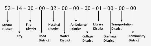
The first two digits are school district code. Please refer to the table below for what each code means.
| Code | School District Name |
|---|---|
| 03 | PLATTSBURG |
| 16 | LAWSON |
| 21 | KEARNEY & HOLT |
| 27 | SMITHVILLE |
| 40 | EXCELSIOR SPRINGS |
| 47 | EAST PLATTE |
| 53 | LIBERTY |
| 56 | MISSOURI CITY |
| 74 | NORTH KANSAS CITY |
The third and fourth digits are city code. The table below shows each code and city name.
| Code | City Name | Code | City Name |
|---|---|---|---|
| 01 |
LIBERTY |
14 |
KANSAS CITY |
| 02 |
EXCELSIOR SPRINGS |
15 |
OAKVIEW |
| 03 |
KEARNEY |
16 |
GLENAIRE |
| 04 |
MISSOURI CITY |
17 |
PRATHERSVILLE |
| 05 |
SMITHVILLE |
18 |
VILLAGE OF OAKS |
| 06 |
HOLT |
19 |
OAKWOOD |
| 07 |
NORTH KANSAS CITY |
20 |
GLADSTONE |
| 08 |
MOSBY |
21 |
PLEASANT VALLEY |
| 09 |
AVONDALE |
23 |
LAWSON |
| 10 |
BIRMINGHAM |
24 |
INDEPENDENCE |
| 11 |
RANDOLPH |
25 |
SUGAR CREEK |
| 12 |
CLAYCOMO |
26 |
EXCELSIOR ESTATES |
| 13 |
OAKWOOD PARK |
29 |
UNINCORPORATED COUNTY |
The fifth and sixth digits are fire district code. The table below shows each code and its corresponding fire district name.
| Code | Fire District Name |
|---|---|
| 01 | SMITHVILLE |
| 02 | KEARNEY |
| 03 | HOLT |
| 04 | LAWSON |
| 05 | FISHING RIVER |
The seventh and eighth digits are road district code. The table below shows each code and its road district name.
| Code | Road District Name |
|---|---|
| 03 | GLADSTONE SPECIAL ROAD DISTRICT |
| 04 | CLAYCOMO SPECIAL ROAD DISTRICT |
| 05 | LIBERTY SPECIAL ROAD DISTRICT |
| 06 | KEARNEY SPECIAL ROAD DISTRICT |
| 08 | PLEASANT VALLEY SPECIAL ROAD DISTRICT |
| 09 | NORTH KANSAS CITY SPECIAL ROAD DISTRICT |
| 10 | CLAY COUNTY SPECIAL ROAD DISTRICT (EXCELSIOR SPRINGS) |
The ninth and tenth digits are hospital district code. The table below shows code and name.
| Code | Hospital District Name |
|---|---|
| 02 | LIBERTY |
The eleventh and twelfth digits are water district code. Below shows each table and its district name.
| Code | Water District Name | Code | Water District Name |
|---|---|---|---|
| 02 |
CLAY COUNTY #2 |
09 |
CLAY COUNTY #9 |
| 03 |
CLAY COUNTY #3 |
11 |
CLAY COUNTY #1 |
| 04 |
CLAY COUNTY #4 |
14 |
CLAY COUNTY #14 |
| 05 |
CLAY COUNTY #5 |
21 |
RAY COUNTY #21 |
| 06 |
CLAY COUNTY #6 |
22 |
RAY COUNTY #22 |
| 07 |
CLAY COUNTY #7 |
38 |
PLATTE COUNTY #8 |
| 08 |
CLAY COUNTY #8 |
The thirteenth and fourteenth digits are ambulance district code. The table below shows code and name.
| Code | Ambulance District Name |
|---|---|
| 01 | SMITHVILLE (i.e. NORTHLAND REGIONAL) |
| 02 | EASTERN CLAY COUNTY |
The fifteenth and sixteenth digits are college district code. Please refer to the table below for what each code means.
| Code | College District Name |
|---|---|
| 01 | METROPOLITAN COMMUNITY |
The seventeenth and eightteenth digits are Library district code. Please refer to the table below for what each code means.
| Code | Library District Name |
|---|---|
| 01 | MID-CONTINENT |
The nineteenth and twentieth digits are Drainage district code. Please refer to the table below for what each code means.
| Code | Drainage District Name |
|---|---|
| 01 | NORTH KANSAS CITY |
| 02 | BIRMINGHAM |
| 03 | RAY-CLAY |
| 04 | TRI-COUNTY |
The twentieth one and twentieth two digits are Transportation district code. Please refer to the table below for what each code means.
| Code | Transportation District Name |
|---|---|
| 01 | TOWER |
| 02 | 210 HIGHWAY |
| 03 | BRIARCLIFF PARKWAY AND HIGHWAY 9 |
| 04 | HOLLY FARMS |
The twentieth three and twentieth four digits are Community district code. Please refer to the table below for what each code means.
| Code | Community District Name |
|---|---|
| 01 | LIBERTY TRIANGLE |
| 02 | LIBERTY TRIANGLE SHOPPING CENTER |
| 03 | TOGERS PLAZA |
| 04 | ANTIOCH CENTER |
| 05 | BLUE JAY CROSSING |
| 06 | LIBERTY DOWNTOWN |
| 07 | HOMESTEAD |